 Español
 Nederlands
 Deutsch
Pileus or Cap Cloud: The Fascinating Hat-Shaped Cloud Over Storms
Meta Description
The Pileus cloud (or Cap Cloud) is a lenticular formation that appears like a “hat” atop developing cumulonimbus clouds. Discover its origin, characteristics, and meteorological significance.
Introduction
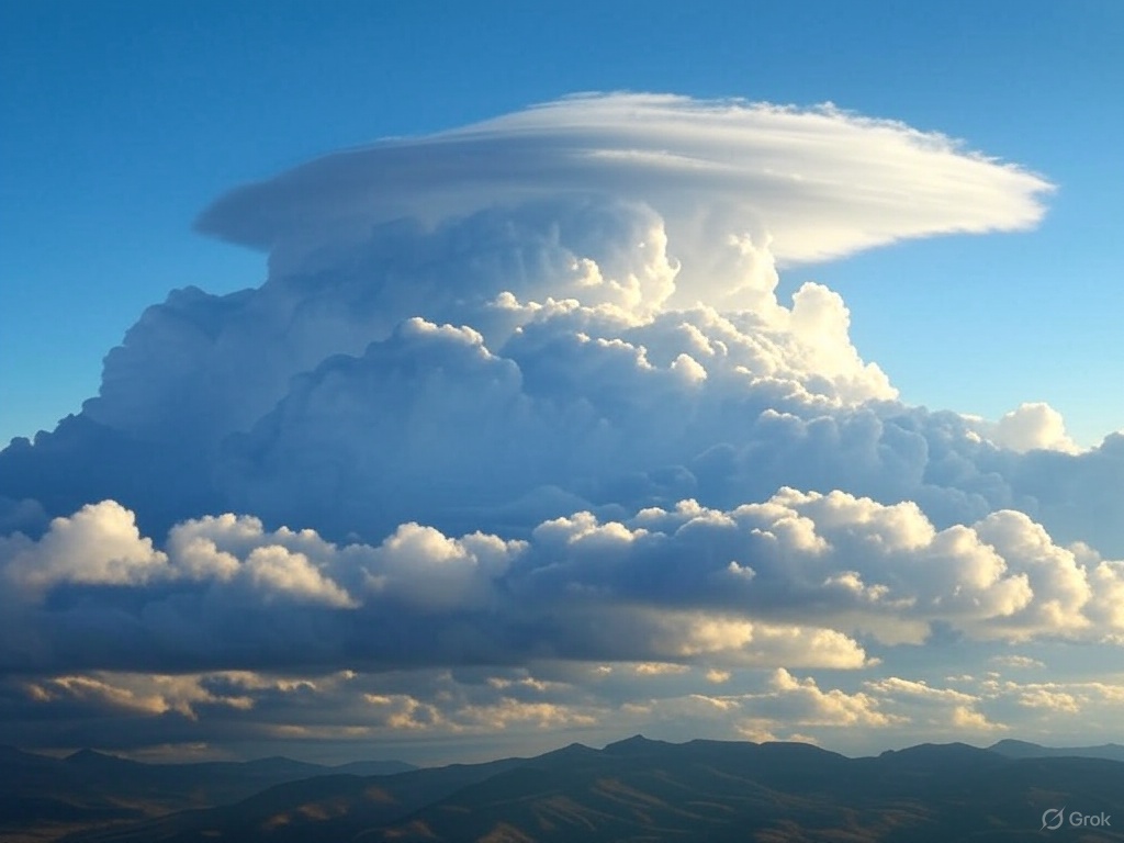
Among the most spectacular and short-lived cloud formations is the Pileus cloud (also called Cap Cloud), a peculiar smooth “hat” that crowns developing convective towers. These clouds are visual indicators of rapid vertical growth in the atmosphere.
In this article, you’ll explore:
✔ What a Pileus cloud is and how it forms
✔ Differences from other lenticular clouds
✔ What it reveals about atmospheric conditions
✔ Where and when to observe them
What Is a Pileus Cloud?
The Pileus (Latin for “hat”) is an accessory cloud that forms when a rising current of moist air (from a developing cumulus or cumulonimbus) is forced to condense upon encountering a stable air layer above.
Key Features:
- Shape: Smooth, lenticular (like a saucer or cap).
- Position: Always atop a convective tower, never isolated.
- Duration: Short-lived (minutes), until the tower pierces through it.
- Color: White, but may show iridescence at sunset.
How Does It Form? Meteorological Process
- Intense updraft: A growing cumulus congestus or cumulonimbus rapidly pushes moist air upward.
- Encounter with stable layer: The moist air reaches a layer where temperature increases with height (temperature inversion).
- Forced condensation: The air cools adiabatically, forming the Pileus.
- Destruction: The convective tower continues growing and eventually pierces the Pileus, dissipating it.
Where and When to See Pileus Clouds?
Common locations:
- Above developing storm towers (especially in spring/summer).
- Near mountains, where uplifted air favors their formation.
Best time:
- Afternoon hours, when convection peaks.
Meteorological Significance
A Pileus cloud indicates:
- Strong atmospheric instability: The underlying tower is growing vigorously.
- Potential future storm: Many Pileus clouds precede mature cumulonimbus.
Differences from Other Lenticular Clouds
| Pileus Cloud | Standard Lenticular Cloud |
|---|---|
| Always attached to cumulus/cumulonimbus | Forms independently over mountains |
| Hat-shaped over convective tower | Isolated saucer shape |
| Short lifespan (minutes) | Can persist for hours |
Fun Facts
- In Roman mythology, “Pileus” was a cap symbolizing freedom (like the cloud “freeing” itself from the tower!).
- Photographing a Pileus is challenging—they vanish quickly.
Key Takeaways
✅ Accessory cloud shaped like a smooth hat over convective towers.
✅ Sign of rapid vertical growth and potential storms.
✅ Ephemeral: lasts only minutes before being pierced.
✅ Don’t confuse with classic lenticular clouds (which are stationary).
FAQ
Q: Can a Pileus produce precipitation?
A: No, it’s just temporary condensation. Rain (if any) comes from the cumulonimbus below it.
Q: Are they visible from satellites?
A: Rarely, due to their small size and brief existence.
Q: Are they dangerous for aviation?
A: Not directly, but their associated cumulonimbus can be.